Computer Aided Design (CAD) and Building Information Systems (BIM)
EgiCAD have developed different fields of interest related to CAD (Computer Aided Design) and BIM (Building Information Management). Both of them are very useful tools for Engineering and Architecture. We work with both of them with two different approaches: as users and as programmers.
We are specialized in the following software:
- Autocad, from Autodesk, in the basic package as well as in Map 3D and Civil 3D (BIM software for civil engineering design and construction). Wide experience in programming environments(LISP, Visual LISP, VBA and ObjectARX). Member of Autodesk Developer Network.
- Microstation, from Bentley, for mechanical design (Modeler) and terrain modelling (Terramodeler).
- Smartsketch, from Intergraph.
- Inventor from Autodesk, parametric design software.
- Revit, from Autodesk, software BIM for design, construction, EMP
- 3D Experience, from Dassault Systèmes, business experience platform, which provides software solutions and powers industry solution experiences, based on 3D design, analysis and simulation in a collaborative environment
- CATIA (Computer-Aided Three-dimensional Interactive Application), from Dassault Systèmes.
Geographic Information Systems (GIS)
- ArcGIS by ESRI, working with both desktop and online plataform. We have many years of experience developing software in MapObjects and ArcObjects.
- GeoMedia by Intergraph, working with both desktop and online plataform, as well as with GeoMedia WebMap.
Visual Impact Assessment (VIA)
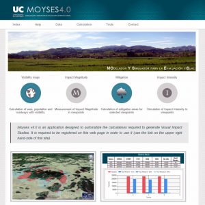
EGICAD is specialized in developing engineering projects focused on simlation environments and visual impact assessment (VIA), not only for windfarms but also for new roads, conventional and high-speed rail lanes, dams, maritime piers and so on. We work with our own softare, MOYSES, letting the user to automatically perform the calculations for the visual impact projects.
Click here for more information.
Geometric design of Space Frames
Some architectural domes, virus, fullerenes, soccer balls and crystals share the same characteristic: they are structures that approximate the sphere. There exist many sys-tems to replicate the shape of a sphere or any other quadric surface, most of them based on the juxtaposition of 3D solids, 2D panels or 1D bars + 0D nodes. The last case corresponds to the so-called space frames, a structural system assembled from linear elements arranged in such a way that forces are transferred in a three-dimensional manner.
This is one of our lines of research, which have been giving many results during the last decades: PhD thesis, papers, projects, patents, software applications, final degree projects, etc.
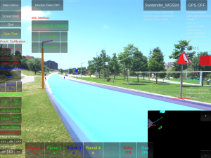
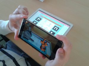
Augmented Reality
Augmented Reality (AR) is a trending technology that provides a live view of the real and physical environment augmented by virtual elements, enhancing the information of the scene with digital information (sound, video, graphics, text or geo-location). Its application to architecture, engineering and construction, and facility management (AEC/FM) is straightforward and can be very useful to improve the on-site work at different stages of the projects.
We have developed several software tools and teaching projects in the field of AR, proving the suitability of this technology in both fields. For example, CEsARe (Construction Engineering software for Augmented Reality) is an application designed to represent in AR, by means of a portable electronic device, the 3D model of the project in the construction site or in any other environment. As a result, the virtual model (and its attached attributes) can be seen superposed to the real scenario of the construction site taken by the camera.
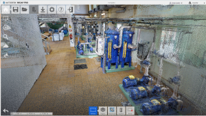
Data Capture
La necesidad de obtener modelos tridimensionales precisos es una necesidad en todos los ámbitos de la ingeniería, para obtener documentación as-built, levantamientos topográficos detallados, ingeniería inversa, impresión 3D, inspección y control de instalaciones industriales, control de infraestructuras, elaboración de documentación digital, etc. En el grupo EgiCAD tenemos experiencia en digitalización de espacios interiores y exteriores mediante el uso combinado de técnicas fotogramétricas (aéreas mediante dron y terrestres), láser escáner y láser RGB-D, obteniendo modelos finales en distintos formatos, como nubes de puntos, mallas texturizadas, modelos en Realidad Virtual y modelos BIM.